My articles archive

Regions of Europe

Bavaria

The Free State of Bavaria (in German: Freistaat Bayern) comprises the entire southeast portion of Germany. It is geographically the largest federal state in the country.

Bavaria is divided in 7 administrative regions: Oberfranken (Upper Franconia), Mittelfranken (Middle Franconia), Unterfranken (Lower Franconia), Bayerisch Schwaben with Allgäu (Bavarian Swabia), Oberpfalz, (Upper Palatinate), Oberbayern (Upper Bavaria), and Niederbayern (Lower Bavaria)

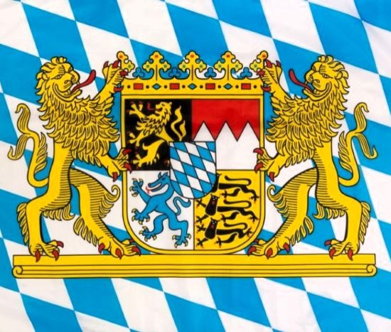
Coat of Arms: The coat of arms of Bavaria has greater and lesser versions. The modern coat of arms was designed by Eduard Ege, following heraldic traditions, in 1946.
First Quarter (The Golden Lion): At the dexter chief, sable, a lion rampant Or, armed and langued gules. This represents the administrative region of Upper Palatinate.
Second Quarter (The Franconian Rake): At the sinister chief, per fess dancetty, gules and argent. This represents the administrative regions of Upper, Middle and Lower Franconia.
Third Quarter (The Blue Panther): At the dexter base, argent, a panther rampant azure, armed Or. This represents the regions of Lower and Upper Bavaria.
Fourth Quarter (The Three Lions): At the sinister base, Or, three lions passant guardant sable, armed gules. This represents Swabia.
The White and Blue Inescutcheon (Herzschild = "Heart Shield"): The escutcheon of white and blue oblique fusils was originally the coat of arms of the counts of Bogen, adopted in 1242 by the House of Wittelsbach. The white and blue fusils are indisputably the emblem of Bavaria and the heart shield today symbolizes Bavaria as a whole.
The People's Crown: The four coat fields with the heart shield in the centre are crowned with a golden band with precious stones decorated with five ornamental leaves. This crown appeared in the coat of arms for the first time in 1923 to symbolize the sovereignty of the people.

Sources: Wikipedia | Nations Online

content-photo

Regions of Europe

Holy Mountain

Mount Athos, also called Holy Mountain (Áyion Óros) has enjoyed an autonomous statute since Byzantine times. It is a unique monastic republic of Orthodox monks inhabiting 20 monasteries and dependencies (skítes), and it is governed by its own local administration.

The monks are detached even from each other, reserving most of their time for prayer and solitude. It occupies the easternmost of the three promontories of the Halkidiki peninsula, which projects from the Macedonia region into the Aegean Sea. The capital and only town of Holy Mountain is Karyes.

Coat of Arms: The Ecumenical Patriarchate and Mount Athos use a black double-headed eagle in a yellow field as their emblem. The eagle is depicted as clutching a sword and an orb with a crown above and between its two heads.

Sources: UNESCO | National Geographic | Britannica | Wikipedia

content-photo

Regions of Europe

Burgenland

Happy birthday, Burgenland (1921-2021)! Burgenland is the easternmost state of Austria, bordering Hungary on the east, Niederösterreich (Lower Austria) on the northwest and Steiermark (Styria) on the southwest. Derived from parts of the four former west Hungarian counties, it became an Austrian federal state in 1921. The name Burgenland means "castle land" due to the large number of castles in the region. Burgenland’s capital is Eisenstadt.

Coat of Arms: A crowned eagle regardant, standing upon a rock with an escutcheon on his breast. In dexter and sinister cantons are two crosslets. The arms were created and officially granted in 1922. The arms are a combination of the arms of the two most powerful families in the area in medieval times. The eagle with crosslets is derived from the arms of the counts of Mattersdorf-Forchtenstein, the breast shield from the arms of the counts of Güssing-Bernstein.

Sources: Wikipedia | Britannica | Heraldry-Wiki

content-photo